
We leave a
car at the take-out in Villanova, about 5km upstream of Dignano as today the
water level is at the minimum runnable. The gauge in Villuzza is at 40. We get
back up to the put-in in Trasaghis, a small town in front of Osoppo and we
cross along the way the Natural Reserve of Cornino Lake, where you can watch
the griffins, recently re-introduced. A real charming
site. The put-in is by
a canal named Leale which is taking us straight to the Tagliamento, some kms
downstream. This first stretch isn’t exactly spectacular, from a landscape standpoint,
but we could run the only rapids of all the descent and it also allows us to
reach the Tagliamento without any issues. The upstream stretch – with this
level – is not runnable by no means. One alternative put-in is possible at the
end of the canal, where the river widens, but well before the confluence.
 Shortly
before the confluence, the landscape changes a lot and it will remain as such
until the take-out. A nice surprise. The sight widens and the eye can’t
feel the whole landscape which it’s provided: at the back the Prealpi Giulie
are the frame in all their beauty, whilst the crystal river now flows in a huge
bed, sometimes it splits in different branches, but we can always spot the
runnable one with more easiness. There’s
virtually no slope and no difficulty either, hence we have all the time and
pleasure in the world to watch the surrounding wild nature. You don’t see any
“human” sign, no artefact, towns, bridges or whatever, at least for about ten
kms. Incredible place! And it seems impossible such a long stretch, so wild if
you consider where we found ourselves, in the middle of Friuli, a heavily
populated area.
Shortly
before the confluence, the landscape changes a lot and it will remain as such
until the take-out. A nice surprise. The sight widens and the eye can’t
feel the whole landscape which it’s provided: at the back the Prealpi Giulie
are the frame in all their beauty, whilst the crystal river now flows in a huge
bed, sometimes it splits in different branches, but we can always spot the
runnable one with more easiness. There’s
virtually no slope and no difficulty either, hence we have all the time and
pleasure in the world to watch the surrounding wild nature. You don’t see any
“human” sign, no artefact, towns, bridges or whatever, at least for about ten
kms. Incredible place! And it seems impossible such a long stretch, so wild if
you consider where we found ourselves, in the middle of Friuli, a heavily
populated area. Then we
reach the Cimano’s bridge, firs sign of civilization and we can also notice
some village in the distance, on the hills, but nothing that is disturbing our
sight that much. Here it’s also the confluence with the Ledra channel which –
thanks to its water flow – will ensure an easier descent even in the secondary
branches. From here up to the Pinzano’s bridge, sometimes on the left side you
can see conformations of conglomerate, typical of this alluvial lowland which
have been dig during the time by the force of the flood. This valley has been
crossed by the Austrian troops during the first world war, therefore you can
see, with some effort, some forts used by the officers during their movements.
Then we
reach the Cimano’s bridge, firs sign of civilization and we can also notice
some village in the distance, on the hills, but nothing that is disturbing our
sight that much. Here it’s also the confluence with the Ledra channel which –
thanks to its water flow – will ensure an easier descent even in the secondary
branches. From here up to the Pinzano’s bridge, sometimes on the left side you
can see conformations of conglomerate, typical of this alluvial lowland which
have been dig during the time by the force of the flood. This valley has been
crossed by the Austrian troops during the first world war, therefore you can
see, with some effort, some forts used by the officers during their movements. 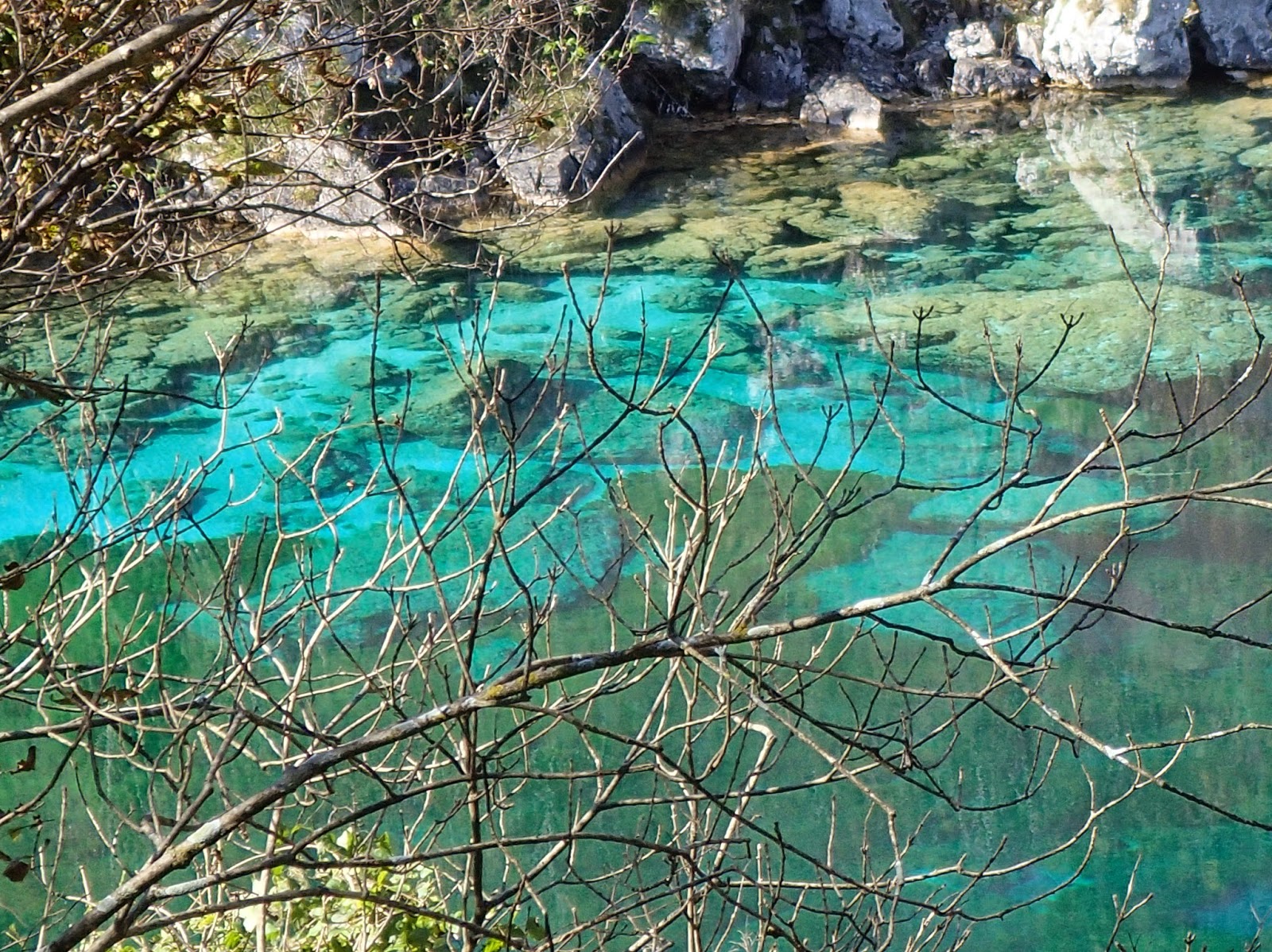
All in all,
a pleasant surprise, an incredible place that lends itself to – according to
the water level – a couple of hours descents or a real river trip of a couple
of days, considering a put-in in the Tagliamento by Bordano and perfectly
suitable to paddlers of any skills, beginners included. For sure an experience
to make.
Alpin
Action FVG organize guided descents or Kayak lessons or multidays river trips
along this spectacular stretch according to your wish.
Be safe in the river
Beppe Caramella

Tagliamento – IT

 Lasciamo una macchina allo sbarco di Villanova
circa 5km più a monte di Dignano in quanto oggi il livello è al minimo
navigabile. L’idrometro di Villuzza segna 40. Risaliamo fino all’imbarco a Trasaghis,
un paese di fronte ad Osoppo e lungo la strada attraversiamo la riserva
naturale del Lago di Cornino, dove si possono osservare i grifoni, recentemente
reintrodotti. Posto incantevole. L’imbarco è su un canale di nome Leale che
lealmente ci trasporta nel Tagliamento qualche km più a valle. Questo primo
tratto non è esattamente spettacolare dal punto di vista paesaggistico, ma ci
regala le uniche rapide di tutta la discesa e ci consente di arrivare al
Tagliamento senza problemi. La parte a monte con questo livello non è
navigabile. Un eventuale altro imbarco è possibile all’uscita del canale, dove
il fiume si allarga, ma ancor prima della confluenza.
Lasciamo una macchina allo sbarco di Villanova
circa 5km più a monte di Dignano in quanto oggi il livello è al minimo
navigabile. L’idrometro di Villuzza segna 40. Risaliamo fino all’imbarco a Trasaghis,
un paese di fronte ad Osoppo e lungo la strada attraversiamo la riserva
naturale del Lago di Cornino, dove si possono osservare i grifoni, recentemente
reintrodotti. Posto incantevole. L’imbarco è su un canale di nome Leale che
lealmente ci trasporta nel Tagliamento qualche km più a valle. Questo primo
tratto non è esattamente spettacolare dal punto di vista paesaggistico, ma ci
regala le uniche rapide di tutta la discesa e ci consente di arrivare al
Tagliamento senza problemi. La parte a monte con questo livello non è
navigabile. Un eventuale altro imbarco è possibile all’uscita del canale, dove
il fiume si allarga, ma ancor prima della confluenza.
 Poco prima della confluenza il paesaggio muta
considerevolmente e rimarrà tale fino allo sbarco. Una piacevole sorpresa. Lo
sguardo si allarga e l’occhio non è in grado di percepire l’intero panorama che
si offre: alle spalle le Prealpi Giulie fanno da cornice in tutto il loro
splendore, mentre il fiume ora scorre cristallino in un enorme letto, talvolta
si divide in diversi rami, ma riusciamo sempre ad individuare quello navigabile
con maggior facilità. Non c’è praticamente dislivello e le difficoltà sono
inesistenti, quindi si ha tutto il tempo e il piacere di osservare quello che
ci circonda, la natura selvaggia. Non si vede alcun segno “umano”, nessun
manufatto, paesi, ponti o quant’altro, almeno per una decina di km abbondanti.
Posto incredibile! E sembra impossibile un tale tratto così lungo, così
selvaggio considerato dove ci troviamo, nel mezzo del Friuli, in una zona
fortemente antropizzata.
Poco prima della confluenza il paesaggio muta
considerevolmente e rimarrà tale fino allo sbarco. Una piacevole sorpresa. Lo
sguardo si allarga e l’occhio non è in grado di percepire l’intero panorama che
si offre: alle spalle le Prealpi Giulie fanno da cornice in tutto il loro
splendore, mentre il fiume ora scorre cristallino in un enorme letto, talvolta
si divide in diversi rami, ma riusciamo sempre ad individuare quello navigabile
con maggior facilità. Non c’è praticamente dislivello e le difficoltà sono
inesistenti, quindi si ha tutto il tempo e il piacere di osservare quello che
ci circonda, la natura selvaggia. Non si vede alcun segno “umano”, nessun
manufatto, paesi, ponti o quant’altro, almeno per una decina di km abbondanti.
Posto incredibile! E sembra impossibile un tale tratto così lungo, così
selvaggio considerato dove ci troviamo, nel mezzo del Friuli, in una zona
fortemente antropizzata.
Poi raggiungiamo il ponte di Cimano, primo
segno umano e si inizia a scorgere qualche villaggio in lontananza sulle
colline, ma nulla che disturba più di tanto la vista. Qui confluisce anche il
canale Ledra che grazie al suo afflusso ci garantirà una discesa più fluida
anche nei rami secondari. Da qui fino al ponte di Pinzano ogni tanto sulla
sinistra si possono osservare conformazioni di conglomerato tipiche di questa
pianura alluvionale che sono state scavate nel tempo dalla forza del fiume in
piena. Questa valle è stata frequentata anche dalle truppe Austriache durante
la prima guerra mondiale e pertanto sono visibili, con qualche sforzo, delle
fortezze utilizzate dagli ufficiali durante gli spostamenti.
 Pian piano dopo tre ore buone di pagaiata
continua giungiamo allo sbarco. Dovremmo aver percorso una distanza tra i 25 e
i 30km, purtroppo nessuno di noi si è ricordato di portare il GPS…
Pian piano dopo tre ore buone di pagaiata
continua giungiamo allo sbarco. Dovremmo aver percorso una distanza tra i 25 e
i 30km, purtroppo nessuno di noi si è ricordato di portare il GPS…
In sostanza, una piacevolissima sorpresa, un
posto incredibile che si presta – a seconda del livello – a discese di un paio
d’ore fino a veri “river trip” di un paio di giorni, considerando l’imbarco nel
Tagliamento a Bordano ed adatto a canoisti di qualsiasi livello, incluso i
principianti. Sicuramente un’esperienza da provare.
Alpin Action FVG organizza discese guidate o
corsi di Kayak o river trip di più giorni lungo questo spettacolare tratto a
seconda delle esigenze.
A presto in fiume
Beppe Caramella


